Today, the old settlement operates as an open-air museum.
Aboriginal people have lived in Australia for thousands of years. On Barrow island, in a cave, near Karratha in Western Australia, archaeologists have found artefacts which have been dated at 50,000 years old. A cave south of Geraldton, which contained eggshells, ochre and animal bones, has been dated at 25,000 years old.
About 600 different tribal groups existed around Australia before European settlement, with differing cultures and beliefs.
The Yamatji people hunted and
collected food from the land, including witchetty grubs, emu eggs, goannas and bush pears. Interestingly, one of the methods the Yamaji people used to cook a kangaroo was by digging a deep hole, making a fire at the bottom, filling the kangaroo’s stomach cavity with hot rocks, putting the kangaroo in the ashes and then putting ash on the top of the kangaroo and leaving it to cook.
 |
| Aboriginal man and his dog returning from hunting kangaroo in the Upper Murchison, ca.1930, SLWA |
George Grey, a European explorer who walked from Kalbarri to Perth in 1839, noted the use of wells by Aboriginal people for accessing water sources. Animal skins were used to carry the water over long distances. Grey also wrote of
seeing fields of yams growing in the Yamaji region.
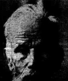
Dreamtime (creation) stories shaped the laws and customs of the Yamatji people. Dingos were often very important to Aboriginal people, helping to keep them warm, find water, and as pets (women would walk about with a dingo draped around their waist). As recently as 110 years ago, Aboriginal men used dingoes to help hunt kangaroos.
 |
| Aboriginal woman carrying a dingo, n.d, NLAUST |
In some Aboriginal cultures, dingos were suckled by women like they were their own children, and dingos have featured in Dreamtime stories and are regarded as ancestors.
The Yamatji people have a particular story where a dingo guardian protects the tribe from an enormous black kangaroo, which explains why the Yamatji often kept at least two dingos about for safety.
 |
| Aboriginal men dressed for corroboree, circa 1900, SLAW |
 |
| EMU FEATHER SLIPPERS: These slippers are worn by me'Boolya' or medicine man of an aboriginal tribe when on special aim secret missions. They are made of emu feathers and practically defy trackers. In the sole of the slipper, on the right is a cleverly concealed receptable to hold two mother of pearl operating knives for tribal ceremonies. This is a rare curio in the possession of Mr. Me Vicker-Smyth, of Elder House, Per th, and was secured by him duringa recent tour of the Murchison. Daily News (Perth, WA : 1882 - 1950), Saturday 10 December 1932 |
1839: Exploration
The area around Greenough was first explored by Europeans when George Grey, in 1839, was looking for more agricultural lands. After which, he named the area after Sir George Bellas Greenough, the president of the Royal Geographical Society
in London
.
Grey's exploration became shipwrecked in Gantheaume Bay and experienced one disaster after another, and all the boats were lost. So Grey and his party
had to walk all the way back to Perth. It was during the walk that Grey came upon Greenough. He said:
"We passed a large assemblage of native huts of the same permanent character as those I have before mentioned: there were two groups of those houses close together in a sequestered nook in a wood, which taken collectively would have contained at least a hundred and fifty natives. We halted for the night in the dry bed of a watercourse, abounding in grass, so that we again enjoyed the luxury of a soft bed. At first I thought that we were near natives from hearing a plaintive cry like that of a child, but Kaiber assured me that it was the cry of the young of the wild turkey."
 |
| Seated portrait of Sir George Grey, a top hat in his hands and a writing desk on his right side, circa 186. PD |
1850s
Reports were spreading from others who trekked into the Greenough area of its suitability for farming land. Greenough is a fertile area due to the presence of lagoons, which existed long ago, that became cut off from the ocean, and over time, the frequent floods of the Greenough River left rich soil behind in the area.
In 1850 cattle and sheep were driven overland from Perth into the Greenough region, and pastoral runs like Glengarry and Ellendale were established. Among those early settlers were Thomas Brown, Major Logue and Edward Hamersley of the cattle company.
Augustus Gregory surveyed 30,000 acres (120 km²) of land in the region in 1851, as well as a road, that became known as the Greenough Flats. In 1857, Augustus Gregory surveyed roads and land allotments of 30,000 acres and the land opened up for settlement.
 |
| Sir Augustus Charles Gregory KCMG FRSGS(1 August 1819 – 25 June 1905) was an English-born Australian explorer and surveyor. |
The first European woman in the district, Eliza Brown, in 1851 arrived at Champion Bay to visit her husband Thomas Brown at the Glengarry homestead. The Colonisation Assurance Company leased 60,000 acres of the Greenough Flats, with
plans to settle immigrant farmers on small blocks. The plan soon failed.
Hamersley and Co. expanded into the Greenough and became a major player in the development of the Flats in 1852.
In 1852, George Shenton exchanged his farm at Wanneroo near Perth for land on the Greenough River flats, now known as Walkaway. He was the director of the Western Australian Bank from 1847 to 1867. Shenton’s relative, William Cousins, grew a wheat crop on this land that was probably the first in the area.
Despite the rich soil, the farmers of Greenough
would struggle due to lack of equipment. Many used spades to till their fields, as they did not even own ploughs.
In July 1853, a mail service was established. A police constable and native tracker carried the mail by horse from Perth.
As the settlement expanded, there was an increase in settler-Aboriginal conflicts.
Settlers
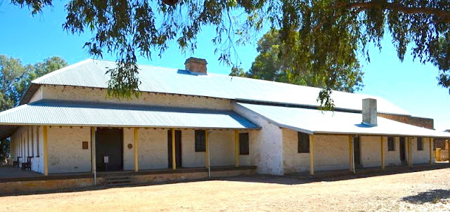
Clinch's Mill was first built in 1854 by Thomas Whitfield and his partner Robert Sutherland, funded by Walter Padbury, the first flour mill in the district. John Maley was the overseer of the construction of the mill. Maley opened a General Store
in 1863 adjacent to the flour mill. Edward Whitfield sold the mill in 1869 to Thomas Clinch.
 |
| Clinch's mill, one of the landmarks of the Greenough district, lt was occupied during the latter part of last century by Thomas Clinch,Western Mail (Perth, WA : 1885 - 1954), Thursday 19 April 1934 |
 |
| Perth Gazette and Independent Journal of Politics and News (WA : 1848 - 1864), Friday 30 September 1859 |
Colonial Secretary Barlee visited the district in 1856 and stated: “it surpasses beyond comparison any part of this colony that I have seen”.
William Criddle was a stonemason who came to the Greenough district in 1857 with his family. The first European
baby born in the district is believed to have been his daughter, Mary. Two of the houses Criddle built were washed away in the floods and the last survived. William Criddle died in 1875.
 |
| Mr. and Mrs. William Criddle, early pioneers of the Greenough district. Western Mail (Perth, WA : 1885 - 1954), Thursday 16 November 1939 |
The partnership of Messrs Edward Hamersley, Samual Phillips and Lockier Burges, operating as the Cattle Company, took up land at Greenough. The partnership dissolved, and Edward Hamersley retained the Greenough holdings, which included Well Station.
A sale of blocks of land occurred in 1857 with land selling at £1 an acre. John Broad, John Rhodes, Edward Tuncliffe and Joseph Coker and their families took up leases.
Guard's Village
In the same year of 1857, a Pensioner Guards village was established at the northern end of the Greenough, near Gregory Road.
One of the Pensioner Guards who settled on the Greenough Flats was Felix Devlin, whose cottages lies in ruins. Pensioner Kelly's Cottage from 1888 survives, as does McNeece's Cottage.
The well-known landmark of the area, Corringle, is the place where the remains of the original "Adlam Cottage" (1868) can be found. Carson’s Cottage was owned by James Carson, a Private in the 57th Regiment. He was allocated land at Greenough and took up the title in 1874.
 |
| Mr Joseph Adlam, arrived from England on the Clara, Hecame here as a guard over convicts, butbefore long obtained a grant of between 200 and 300 acres of land at the Greenough |
Rock of Ages
Ex-convict John Patience built the cottage named "Rock of Ages" in 1857.
 |
| Ex-onvict John Patience built "Rock of Ages" near Greenough, WA, circa 1857 |
Temperance League
Frederick Waldeck took up land on the Front Flats in 1857, but the family did not move to their property, Mount Pleasant, until 1860.
Waldeck donated land in 1861 to the Greenough School Committee, which had raised money by public subscription
for providing a school, to the district. However, the school closed in 1863, and the building was used as a Lodge for the Temperance League.
 |
| Ruins of the schoolhouse and later, Temperance League, Greenough, WA |
Farmers' Club
In 1858 Alex Dewar was granted the lease of land. In 1896, Thomas Clinch purchased the property and gave the land to the Greenough Farmers' Club.
Joseph Green was granted a lease in 1858 for land which
would later be the site of Waldeck’s Cottage, Stone Barn and Wesley Church.
During the 1860s the future for Greenough was looking bright, with over a thousand people living in the area.
 |
| Walter Padbury's steam powered flour mill at Greenough, later known as Maley's Mill, ca. 1860, SLWA. The first flour mill in the district built by Walter Padbury and extended by Thomas Church |
 |
| Stone barn, built 1860s built by ticket-of-leave convict labour. James Smith took up the title in 1877. The property was later owned by J.S. Maley of Home Cottage |
Gray's Store
Gray's Store & Residence was built in 1861 by Henry Gray using convict labour. The two-storey part of the building was used as a residence for the Gray family, while the single-story part was the store.
Behind the store is an unusual water cistern built of stone with a vaulted roof. The building was damaged by fire in 1975.
John S. Maley and Elizabeth K. Waldeck were married at Gray's Store in 1862, as no churches existed at Greenough at the time.
 |
| Gray's store and residence, circa 1861, Greenough, WA |
 |
| Victorian Express (Geraldton, WA : 1878 - 1894), Wednesday 13 September 1882 |
Police Station & Gaol
Police were first stationed at Greenough in 1863, and in 1865, Maitland Brown was appointed the first Resident Magistrate. The Police Station & Gaol began construction in 1870 and cost about £1,500.
 |
| The construction of the Greenough Police Station & Goal began in 1870 and cost about 1,500 pounds, Greenough, WA |
Hampton Arms Inn
Hampton Arms Inn, the first hotel in the Greenough area, was built in 1863, by Robert Pearson.
 |
| Hampton Arms Inn, the first hotel in the area, was built in 1863 by Robert Pearson |
 |
| Victorian Express (Geraldton, WA : 1878 - 1894), Wednesday 27 November 1878 |
School Days
Central Greenough School was built by William Trigg in 1865. The building has also been used as an Anglican church and a community hall.
 |
| Central Greenough School was built by William Trigg in 1865, Greenough, WA |
A Mechanics Institute was built in 1868, on land donated by J.S. Maley adjacent to his Mill on the Front Flats in Phillips Road.
Wesleyan Methodist Chapel
The Wesleyan Church, which is located opposite Gray's Store, is a tall Victorian Gothic Revival random rubble limestone building, which was built in 1867, using ticket of leave labour. Land for the church was donated by John Mills. This building is historically important due to the large Wesleyan Community, which existed during the town's heyday, and the connection to the Waldeck family.
There were 162 houses in the Greenough area in 1870.
St. James Church
St. James Church in South Greenough, Western Australia was built in 1872. The church survived the terrible floods of 1888 and continued to be a place of worship until 1961. Shortly afterwards, the building was
saved from demolition by the local community.
 |
| St. James Church in South Greenough, Western Australia, was built in 1872 |
A cyclone in 1872 caused great destruction and loss of property.
Business
 |
| Victorian Express (Geraldton, WA : 1878 - 1894), Wednesday 6 April 1881 |
 |
| Geraldton Observer (WA : 1880 - 1881), Tuesday 15 March 1881 |
Major flooding occurred in 1888. Then the discovery of gold in Western Australia during the 1990s led to the gradual decline of the population of Greenough. The construction of the railway line through Walkaway in 1894 and rust diseases in the wheat also impacted the prosperity of the area.
St Catherine's Hall
St Catherine's Hall, which is built of locally quarried limestone opened on 4 May 1898, celebrated with a concert and a dance.
 |
| St. Catherine’s Hall built 1898, Greenough, WA. Built in Victorian Georgian style |
Presentation Convent
The convent at Greenough housed the Dominican sisters who arrived from New Zealand in 1899. The Dominican sisters moved to Dongara in 1901 and the Presentation Sisters then took over the building and ran a boys' boarding school.
 |
| Greenough Presentation Convent, WA W.A. Record (Perth, WA : 1888 - 1922), Saturday 10 December 1904 |
 |
| Greenough Convent, WA, circa 1898 |
The Presbytery
The Presbytery was built in 1900 on the former site of Edward Whitfield's proper
ty, by Mr Bennett, furnished by the church,
and housed the local priest for thirty years.
 |
| The presbytery was built in 1900 by Mr Bennett and housed the local priest for thirty years |
Road Board
A permanent one-room stone office in Gregory Road, Greenough, constructed of rubble limestone, was built in 1906. The Greenough Road Board was formed in 1871, with early meetings at the Hampton Hotel. The first meeting of the Greenough Road Board was held in the office on 4 September 1906. The last meeting was held there on 11 March 1952.
 |
| The Road Board building was built in 1906, Greenough, WA |
Farming Days
 |
| Harold Clinch's farm, Greenough, WA, Western Mail (Perth, WA : 1885 - 1954), Friday 27 September 1912 |
Anglican Church
The first Anglican Church of Greenough was built in 1892 of iron and timber. The building had been shipped out from England complete with all fittings and assembled on Company Rd. In 1913, St Catherine’s Church, the second Anglican Church, replaced the former timber building.
 |
| Built in 1913, St Catherine’s Church, Greenough, WA, built |
Greenough Scene
 |
| Scene on the Greenough River, Western Mail (Perth, WA : 1885 - 1954), Thursday 25 September 1919 |
1940s
 |
| A general view of the Greenough flats on which the show was held. Western Mail (Perth, WA : 1885 - 1954), Thursday 17 October 1940 |
Leaning Tree
 |
| Leaning tree of Greenough, WA |
Ned and Harriet Hackett
Ned and Harriet Hackett ran a store next-to their home. Ned also worked as a blacksmith, cobbler, carpenter and undertaker. The cottage was built after the 1888 flood.
 |
| Ned and Harriet Hackett, ran a store next-to their home. Ned also worked as a blacksmith, cobbler, carpenter and undertaker. The cottage was built after the 1888 flood |
Catholic Church and Goodwin's Cottage
The St Peter's Catholic Church was built in 1908; an earlier church had been destroyed by floods in 1888. The cottage next-door was built in 1890, for Ned Goodwin, a retired policeman and his wife. When Ned died in 1912, the building returned to the church. The Presentation Sisters used the cottage as a school until 1958, demolishing a wall between two small rooms to make one large schoolroom.
 |
| St Peter's Catholic church that was designed and built by W. Martin in 1908. An earlier church was destroyed by the 1888 flood |
The Greenough/Walkaway Heritage Trail is a 57 km drive though an attractive rural landscape and buildings from the early settlement of the area. is a 57km drive
Around Greennough
 |
| Clinch's Mill, a late nineteenth century former mill complex built in the Victorian Georgian style, was constructed in 1859 |
 |
| Greenough Museum and Gardens, set in the 19th century former Maley family homestead, Greenough, WA |
 |
| The presbytery was built in 1900 by Mr Bennett and housed the local priest for thirty years, Greenough, WA |
 |
| Central Greenough School was built by William Trigg in 1865, Greenough, WA |
 |
| The construction of the Greenough Police Station & Gaol began in 1870 and cost about 1,500 pounds, Greenough, WA |
 |
| Greennough, WA |
 |
| The construction of the Greenough Police Station & Gaol began in 1870 and cost about 1,500 pounds, Greenough, WA |
 |
| Gray's store and residence, circa 1861, Greenough, WA |
 |
| Abandoned cottage, Greenough, WA |
 |
| Cliff Grange, residence of the manager of the Mill, Greenough, WA |
 |
| This bridge at Greenough, WA, was built in 1864, designed by John S Maley and built by ticket-of-leave convict labour |
Things To Do and Places To Go
Greenough Museum on Phillips Road, Greenough is open daily between 8.30 am and 3.00 pm (Fridays 12.30 pm closing).


